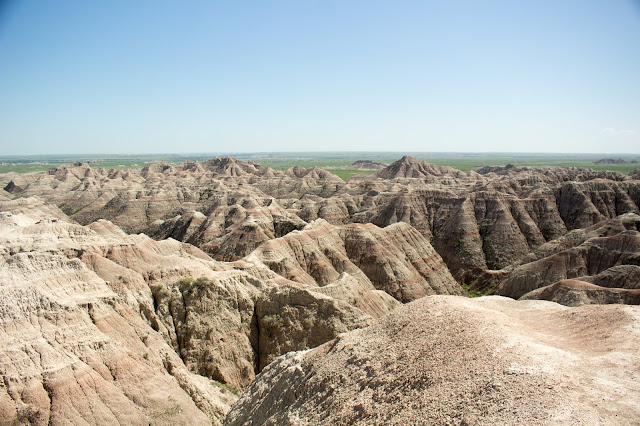
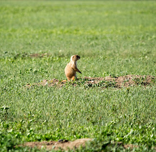
We rose a bit late and didn't take time for breakfast, although we did have coffee with some of that lovely Irish cream we'd bought yesterday. We hopped on to I-90 for the flat, boring ride to the Badlands.
After a while, we stopped for a picnic at a rest area that was being battered by wind whipping over the plains. It made us wonder about the people who once seasonally inhabited these plains. How rugged an existence!
On the road again, we spied this humorous roadside sign:
Sue has a friend who is a ranger at Badlands, and she had arranged for us to meet up so he could give us a tour. We arrived a bit early, so we ventured into the park by ourselves. Found a "road less traveled" where I could dawdle as I shot picture after picture.

The Badlands got their name from the Lakota. Finding extreme temperatures, scarce water, and rugged rock formations, the Lakota called the area “mako sica” or “land bad”. Perhaps not so coincidentally, early French trappers called this place "les mauvaises terres à traverser", or "the bad lands to cross".
They talk about the dynamic landscape of the Badlands, and how their look changes throughout the day, as the sun arcs from sunup to sunset. The change can be almost a minute-by-minute, and I found myself wishing that we'd allotted far more time to this park, to see how it would look in the rosy glow of dawn or the rapidly-changing light of sunset.
Brad arrived and while he and Sue went into the Minuteman Site, Henry and I stayed outside. I tried to be more appreciative of the wind, and succeeded, taking this pretty shot of the sky which could only have been possible with winds:
then Brad gave us access to the paleontology lab at the Ben Reifel Visitor Center -- which has not yet been opened to the public for the season. Though Brad is still fairly new to the park, he's obviously very quickly getting up to speed on discussing its unique geology, flora/fauna, and paleontological discoveries.
The remainder of our time with Brad was spent making our way to and through the Pine Ridge reservation, weaving in and out of the park, and much of the trip was along gravel roads.
It wasn't so evident in any of the previous photos, but here you can clearly see some of the different layers in the Badlands buttes. The Badlands area was once covered by a giant sea, and the oldest fossils are of marine animals. As I understand it, the reddish layers you see are bands of sandstone marking the course of ancient rivers that flowed from the Black Hills. The rugged peaks were once volcanic ash deposits, now hardened but still fragile.
The grayish layers are from the river flood plain, a lush subtropical forest, that replaced the ancient sea. Each time the rivers flooded, they deposited a new layer on the plain.
These yellow mounds were one of my favorite sights in the Badlands. The sea drained away with the uplift of the Black Hills and the Rocky Mountains, exposing black ocean mud to the air. Upper layers weathered into this yellow soil. Geologists don't completely understand this particular layer.
Looking toward the Pinnacles, from Yellow Mounds Overlook.
Moving beyond the Yellow Mounds, these Bighorn Sheep had attracted quite a crowd ...
but as I happily snapped pictures, Sue's attention was drawn to a man who was quietly eating his lunch, and ever so casually checking out a different scene:
No one else noticed the babies, and no wonder! Their coloring is perfect camouflage for the rocky, scrubby terrain.
This Bighorn couldn't have cared less about the fact that I was taking her picture from a car only a few feet away.
The Prairie Dogs are a tourist favorite, as are the Bison.
The next two photos were taken in Scenic. Yes, there is a town named Scenic. And notice the 1906 version of the "We reserve the right to refuse service ... " sign.
Sue, with Brad
I'll be honest with ya: After parting company with Brad, we weren't 100% certain where we were. Swell. Last year, low on gas, we got lost on the Zuni Reservation (New Mexico). This year, low on gas, not as lost -- but still lost! -- in Oglala Lakota territory. But eventually we ended up at this town called Buffalo Gap, which seems to be revitalizing as an artist community.
Once in Buffalo Gap, we were back onto Rand McNally Atlas territory, and easily found our way to the Hot Springs KOA, where we'll be spending the next few nights.
As Henry and I took his last walkie of the night before bed, we went down a lane that was bordered on both sides by high trees. The trees shielded us from the lights of the campground, and the effect was that millions of stars appeared to pop out! I have never before experienced such total darkness, which was only possible because there were no street lights and we were far, far away from the light pollution of a city. It was amazing!
More photos from the Forces of Nature Tour at Flickr.
Click here.


No comments:
Post a Comment